Category 5 Hurricane Lee Gains Strength, Poses Threat to U.S. East Coast
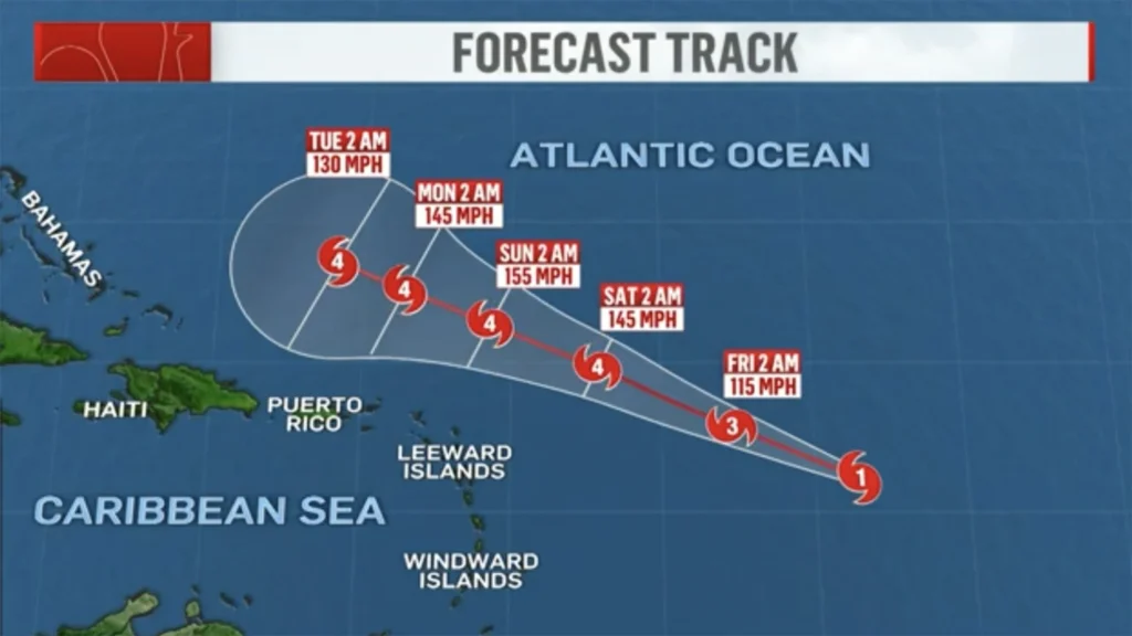
Hurricane Lee has intensified to a Category 5 hurricane in the Atlantic Ocean, according to the National Hurricane Center. As of 11 p.m. Thursday, Lee’s winds had reached a powerful 160 mph, doubling in speed over a 24-hour period. The hurricane is predicted to continue strengthening, with wind speeds expected to reach 180 mph by Friday morning.
While Hurricane Lee remains far from the U.S. coastline, the National Hurricane Center has cautioned that “dangerous surf and rip currents are expected along most of the U.S. East Coast beginning Sunday.” The potential impact of Lee on the U.S. East Coast, including whether it will make landfall or veer out to sea, remains uncertain.
In addition to Hurricane Lee, the Atlantic Ocean has seen the formation of the season’s 13th named storm, Margot. Positioned approximately 290 miles west-northwest of the Cabo Verde Islands, Margot is forecast to become a hurricane over the weekend and is projected to move northward in the Atlantic, away from land.
Lee is the fourth hurricane of the 2023 Atlantic season. Forecasters had accurately predicted its rapid intensification to Category 5 strength, with its top winds expected to be 15 mph higher than initially forecast earlier in the day.
As of 11 p.m. Thursday, Hurricane Lee was situated about 700 miles east of the northern Leeward Islands in the northeastern Caribbean, moving to the west-northwest at 14 mph. The hurricane center anticipates further strengthening due to favorable environmental conditions, including low wind shear and warm waters.
Long-term forecasts suggest that Hurricane Lee is likely to curve northward next week, potentially bypassing Florida. However, the exact path and potential impacts along the U.S. East Coast remain uncertain.
The Atlantic has witnessed a significant increase in Category 5 hurricanes since 2016, including Matthew in 2016, Irma in 2017, Maria in 2017, Michael in 2018, Dorian in 2019, and Ian in 2022.
Despite its rapid intensification, Hurricane Lee is not the fastest storm to reach Category 5 status in the Atlantic. That record belongs to Hurricane Wilma in October 2005, which escalated from a tropical storm to a Category 5 hurricane in just 24 hours. Wilma also holds the record for the lowest barometric pressure in an Atlantic storm, registering at 882 millibars.
While Hurricane Lee’s immediate path is expected to remain over the open Atlantic, the latest forecasts indicate potential variations in its trajectory, ranging from a possible landfall in the Canadian Maritime provinces or the U.S. East Coast north of Florida to a recurvature to the northeast, moving out to sea.
Meteorologist Jeff Masters of Yale Climate Connections stated, “An eventual landfall in the Canadian Maritime provinces or the U.S. East Coast north of Florida is possible after Lee passes Bermuda, as is a recurvature to the northeast, out to sea.”
The storm is expected to generate swells that will affect various regions, including the Lesser Antilles, the British and U.S. Virgin Islands, Puerto Rico, Hispaniola, the Bahamas, and Bermuda. These swells are likely to result in life-threatening surf and rip current conditions.
The 2023 Atlantic hurricane season has already seen the formation of 12 named storms and four hurricanes, with Lee being the third Category 4 storm this year. This season’s heightened activity aligns with predictions for an above-average hurricane season.